
Just a few hours’ drive from Akureyri, the northeast of Iceland is a mix of curving highlands, dramatic canyons and bubbling mud pits. One of the best locations is Jokulsargljufur National Park, home to three forceful and elegant waterfalls, canyons and craters.
## Exploring the Wonders of Jökulsárgljúfur National Park
Jökulsárgljúfur National Park, a sprawling expanse of untamed beauty, graces the remote reaches of northeast Iceland. This remarkable natural area is a haven for adventurous hikers and devoted waterfall enthusiasts alike. Its fame stems from a collection of truly outstanding landmarks, features that captivate the imagination and stir a sense of awe. These include the majestic trio of waterfalls cascading on the park’s southern edge, the enigmatic formations of Hljóðaklettar and Rauðhólar nestled in the heart of the park, and the imposing grandeur of Ásbyrgi Canyon, dominating the northern landscape. The park is generously endowed with an abundance of hiking trails, each offering a unique perspective on the region’s natural splendor. A single day spent exploring Jökulsárgljúfur National Park could easily be filled with unforgettable experiences. However, to truly immerse yourself in its diverse landscapes and appreciate its hidden gems, an extended visit of at least two or three days is highly recommended. This allows ample time to venture deeper into the park’s heart, discovering its secrets at a more leisurely pace.
## The Waterfalls: Dettifoss, Selfoss, and Hafragilsfoss
The southern end of Jökulsárgljúfur National Park is punctuated by the triumvirate of Dettifoss, Selfoss and Hafragilsfoss, all of which offer unique experiences to visitors willing to visit each one.
### Dettifoss: The Untamed Power of Nature
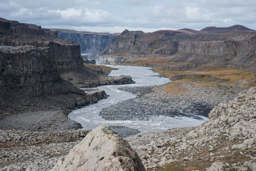
Dettifoss reigns supreme as the most powerful waterfall in all of Europe. Witnessing its raw energy is an experience that will leave you breathless. Imagine a staggering 6,816 cubic feet of water surging over the precipice every single second! The sheer force of the water is palpable, creating a mesmerizing spectacle of nature’s unbridled might. This awe-inspiring waterfall even played a memorable role in the film Prometheus, where its churning waters served as the backdrop for a pivotal scene. The water source for Dettifoss is the wide Jökulsá á Fjöllum river. This river, in turn, is fed by the meltwater from the nearby Vatnajökull glacier, Iceland’s largest ice cap. The falls themselves are a formidable sight, stretching approximately 330 feet (100 meters) in width. The water plunges dramatically 144 feet (44 meters) down into the rugged depths of the Jökulsárgljúfur Canyon, creating a thunderous roar that reverberates through the surrounding landscape. The hike from the parking lot to the edge of Dettifoss is generally a straightforward affair, taking the average hiker less than 10 minutes. However, it’s important to note that during the winter months, the trail can become icy and treacherous, requiring sturdy hiking boots with good traction. As you approach the edge of the falls, exercise caution, as the cliffsides can be slick due to the constant mist and the presence of ice.
### Selfoss: A Cascade of Beauty
Just less than a mile upstream from the mighty Dettifoss, lies Selfoss, a waterfall that exudes a different kind of charm. While Dettifoss commands attention with its sheer power, Selfoss captivates with its serene beauty. Both waterfalls share the same source, the Jökulsá á Fjöllum river. The meltwater from the Vatnajökull glacier embarks on a long journey northward, eventually cascading down the 36-foot (11-meter) drop at Selfoss. From there, the water continues its relentless flow, ultimately joining the torrents of Dettifoss. Selfoss presents a series of smaller cascades that spread across the width of the river, creating a visually stunning spectacle. The water flows gently over the rocks, creating a mesmerizing curtain of shimmering spray.
### Hafragilsfoss: A Hidden Gem
Venture downstream from Dettifoss, and you’ll discover Hafragilsfoss, another waterfall that adds to the dramatic tapestry of Jökulsárgljúfur National Park. Hafragilsfoss plunges approximately 89 feet (27 meters), unleashing a thunderous roar as the water crashes into the depths below. The muddy-white glacier water rushes headlong into the Jökulsárgljúfur Canyon, accessible from both sides of the river. Reaching Hafragilsfoss requires a bit more effort, but the reward is well worth the journey. To get there, begin by driving along the Ring Road (Route 1). Cross the bridge and then make an almost immediate turn onto Road Nr. 864. Be prepared for a gravel road, which can be challenging to navigate, especially in adverse weather conditions. After traveling approximately 20 miles (32 km), you’ll arrive at the parking lot that serves as the starting point for your exploration of Hafragilsfoss.
## Ásbyrgi Canyon: A Geological Marvel Steeped in Legend
The colossal Ásbyrgi Canyon stands as a monumental landmark near Route 85, its distinctive U-shape carving a dramatic impression into the landscape. Stretching approximately 3.5 km (2 miles) from north to south, the canyon is truly awe-inspiring in its scale. Nestled at the base of the canyon lies a verdant forested valley, a stark contrast to the towering cliffs that surround it. Adding to the canyon’s intrigue is a prominent rock island that rises from the valley floor, further enhancing its unique character. A visit to the Ásbyrgi Visitor Center is highly recommended. Here, you can gather valuable information about the canyon’s history, geology, and hiking trails. Pick up maps to guide your exploration and learn about the various points of interest within the area. Geologists have determined that the canyon’s formation is the result of cataclysmic flooding events that occurred approximately 10,000 years ago, and again 3,000 years ago. However, local folklore offers a more fantastical explanation. According to legend, Ásbyrgi was created by the chief god Odin’s eight-legged horse, Sleipnir. It is said that the horse’s hoof stamped into the earth, forming the canyon’s signature horseshoe curve.
There are two distinct roads that run along either side of the canyon, but they do not connect. The road on the eastern side is unpaved, offering more rustic experience. It offers spectacular views overlooking the canyon. This route will take you a bit closer to Dettifoss, although the views of the waterfall are from the side. The road on the western side is paved from the Ring Road and generally easier to manage, but the pavement ends north of Dettifoss. Many of the park’s hiking trails originate on this side of the canyon, making it a popular choice for those seeking to explore the area on foot.
## Unforgettable Hikes Within Jökulsárgljúfur National Park
Jökulsárgljúfur National Park is a paradise for hikers, offering a wide range of trails that cater to different skill levels and preferences.
### Exploring the Waterfalls: A Scenic Loop
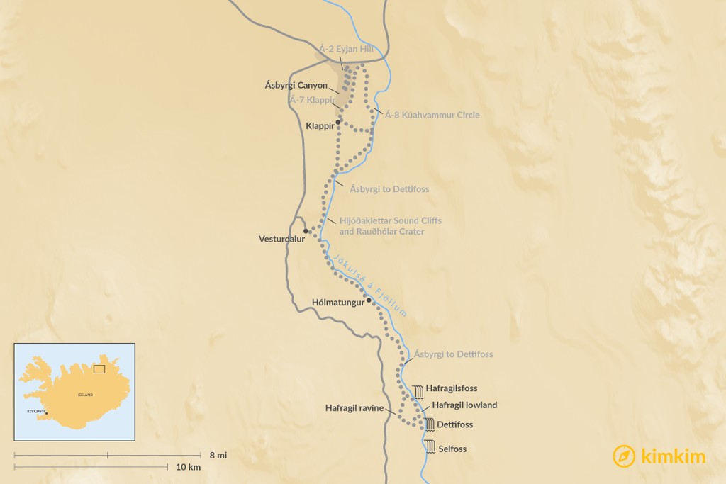
For an up-close and personal encounter with the park’s iconic waterfalls, embark on a hike that takes you to the viewing areas of Dettifoss. One viewing area is positioned higher, providing a panoramic vista of the falls and the surrounding landscape. The other viewing area is located right next to the falls, allowing you to feel the spray of the water and experience the full force of nature. Follow the trail along the cliffside and its basalt columns toward Selfoss. From Selfoss, you have the option to return to the parking lot or continue onward to Hafragilsfoss, completing the loop. The total distance for this captivating hike is approximately seven kilometers. Allow about two hours to fully enjoy the experience.
### Á-2 Eyjan Hill in Ásbyrgi: A Quick Ascent
For a shorter, less strenuous hike with rewarding views, choose the Á-2 Eyjan Hill trail in Ásbyrgi. This hike should take only 1.5 to 2 hours to complete. Follow the wooden steps upward for a pleasant stroll to Eyjan Island, located in the middle of Ásbyrgi Canyon. From the top of the island, you’ll be rewarded with stunning views of the verdant southern landscape. The total distance for this hike is approximately 3 miles (4.5 km).
### Á-7 Klappir in Ásbyrgi: A Panoramic Vista
The Á-7 Klappir hike in Ásbyrgi is considered the “main hike,” taking you from the Visitor Center to some of the most breathtaking viewpoints in the canyon. The trail involves ascending steep stairs and using rope chains to reach the summit of the canyon. Once at the top, you can gaze out over Ásbyrgi and explore the unique potholes at Klappir. This hike offers a truly immersive experience, providing a panoramic perspective of the canyon’s grandeur. The total distance is approximately 5.5 miles (9 km), and the duration is typically 2.5 to 3 hours.
### Á-8 Kúahvammur Circle in Ásbyrgi: A Challenging Loop
The loop around Kúahvammur offers spectacular views over Ásbyrgi and the Jökulsá river canyon. The trail takes you from the Visitor’s Center along the eastern rim of the canyon, extending as far south as Klappir. From Klappir, head east over the moor and along the gorge, passing Gilsbakki and Ás until you reach the starting point. This hike is similar to the main Klappir hike, but it involves a bit more challenge and is slightly longer. The total distance is approximately 7.5 miles (12 km), and the duration is typically around 4.5 hours.
### Hljóðaklettar Sound Cliffs and Rauðhólar Crater: A Symphony of Nature
This hike is widely regarded as one of the best in the park, offering a scenic and relatively easy adventure. The trail loops from the parking area just past Vesturdalur on the west side of the canyon. As you hike, you’ll encounter intriguing basalt columns, fuzzy willow trees, and a winding river. The basalt columns are renowned for their curious echoes. Shout out into the valley, and the basalt rocks will return the echo back and forth, creating a cascading cacophony of sound. For the best spot to witness this phenomenon, head to the marked turnoff for Kirkjan (or “church,” referring to a cave). You’ll also pass a crater colored with red gravel, known as Rauðhólar. The trail is a bit uneven in places, but otherwise not difficult. The total distance is approximately 4 miles (6.5 km), and the duration is about 2 hours.
### Two-Day Trek from Ásbyrgi to Dettifoss: An Immersive Journey
Ambitious hikers seeking a truly unforgettable experience can embark on a multi-day trek from Ásbyrgi to Dettifoss or vice-versa. This challenging hike takes you through the luxuriant Jökulsárgljúfur Canyon, where you’ll encounter impressive gorges, clear springs, lush forests, and quiet plains. The total distance is approximately 20 miles (32 km), and you can start from either direction.
From Ásbyrgi to Vesturdalur, you have two routes to choose from: one along the rim of Ásbyrgi and south along Klappir (12 km), and the other closer to the river (13.6 km). From Vesturdalur, continue about 8 km to Hólmatungur, where you’ll need to cross the small, cold river of Stallá. From Hólmatungur, continue onto Dettifoss. Here, you can opt for the Hafragil lowland (10 km) or take the Hafragil ravine (11.5 km). The lowland route is more difficult and not recommended for hikers carrying heavy burdens. The trail passes through areas with a risk of falling rocks and includes steep sections where you may need to use ropes for support. If you don’t have sure footing, are scared of heights, or are carrying heavy packs, choose the ravine route.
Camping is only permitted at official campsites in Ásbyrgi, Vesturdalur, and at Dettifoss. There are no cabins or mountain huts along this route.
## Essential Information for Your Visit
### Optimal Time to Visit
Summer in Jökulsárgljúfur National Park is undeniably stunning, which is fortunate considering it’s the only season when the area is generally accessible to the public. The roads leading to the park typically close each year for the entire winter season, with the specific closure dates varying depending on the prevailing weather conditions. However, there are winter tour options available for those seeking private guided expeditions.
### Reaching the Park
To get to Jökulsárgljúfur National Park, you can take either the tarmac Route 862 or the gravel Route 864. During periods of adverse weather in winter, the roads can be closed, and hiking routes may become inaccessible. Before embarking on your journey, be sure to check the weather forecast and trail conditions to ensure a safe and enjoyable experience.
### Accommodation Options
For lodging options near Jökulsárgljúfur National Park, consider staying in the nearby town of Húsavík, located approximately 45 minutes westward. The Husavik Cape Hotel is a charming 16-room hotel that offers breathtaking views of Skjálfandi Bay. For a more rustic and secluded experience, try the Kaldbakskot Cottages, featuring 18 newly built log cabins ranging in size from 20 to 30 square meters.
B-1147