
Landmannalaugar is a geothermal wonderland in the Fjallabak Nature Reserve, home to lava fields, hot pools, and steam puffs that rise from the earth. Hike among vibrantly hued mountains and explore highlands dotted with glaciers, black sand beaches, geysers, and waterfalls. Stunning and remote, this area is a perfect representation of all the Icelandic landscape has to offer.
The highlands of Landmannalaugar, a truly remarkable region in Iceland, beckon adventurers with their unparalleled beauty and unique geological features. This otherworldly landscape is celebrated for its vibrant, multicolored mountains, a spectacle for the eyes that is unlike anything else you will encounter. Adding to the mystique are the steamy, spring-fed streams, offering a soothing contrast to the rugged terrain.
For those who enjoy exploring on foot, Landmannalaugar presents a diverse range of hiking opportunities. One popular option is the 4-5 hour trek that meanders through the otherworldly Laugaharaun lava fields. This surreal landscape is a testament to Iceland’s volcanic origins, with jagged rocks and unique formations stretching as far as the eye can see. The trail then leads you through the dramatic Vondugil canyon, a deep gorge carved by centuries of erosion, offering breathtaking views at every turn.
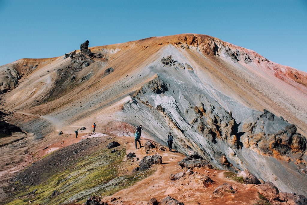
As you continue your journey, you’ll encounter Mt. Brennisteinsalda, a sulfur-skinned mountain that adds another layer of color and intrigue to the landscape. Its steaming vents and sulfur deposits serve as a reminder of the geothermal activity that lies beneath the surface. From there, the path descends into Graenagil, a vividly green gorge that further showcases the region’s remarkable geological diversity. The vibrant colors of the rhyolite rock create a striking contrast against the surrounding landscape.
If time and weather permit, a climb to the Blahnukur Summit is highly recommended. This vantage point offers panoramic views of the entire Landmannalaugar region, allowing you to fully appreciate the scale and beauty of this unique environment. From the summit, you can gaze upon the multicolored mountains, the vast lava fields, and the winding rivers that carve their way through the landscape.
And after a long day of hiking, don’t forget to pack your swimsuit! Landmannalaugar is also known for its geothermal pools, natural hot springs where you can relax and rejuvenate your muscles. Soaking in these warm, mineral-rich waters is the perfect way to end a day of exploring the Icelandic highlands.
## Getting There: Planning Your Journey to Landmannalaugar
Accessing Landmannalaugar requires careful planning, as the region is only accessible during the summer months. The specific dates when the roads leading to the area become accessible vary each year, depending on the prevailing weather conditions. These roads are typically only open when the snow has melted and the rivers are safe to cross.
The road from the north, designated as F208 and accessible via The Highland Centre at Hrauneyjar, is generally the most reliable route. This road is well-paved, making it a relatively smooth drive, and it typically opens in mid-June. This makes it a popular choice for those seeking easier access to Landmannalaugar.
Road F225, the western route, is another option that generally opens around the same time, usually in June. This road offers a different perspective of the landscape, with its own unique charm and scenic views.
The third option is F208 from the south. While this route is often considered the most visually rewarding, offering stunning panoramic vistas, it is also the most challenging to drive. The roads are rougher and more demanding, requiring a vehicle with high clearance and four-wheel drive. From the junction with Highway 1, expect a 2-3 hour journey to get into the park, and be prepared for river crossings and uneven terrain.
Before embarking on your journey, it is crucial to check with the Public Road Administration (Vegagerdin) for the most up-to-date information on road conditions and park access. Their website provides real-time updates on road closures, weather warnings, and other important information to help you plan your trip safely.
For those who prefer not to drive, there are several daily scheduled buses that travel from Reykjavik BSÍ Bus Terminal to Landmannalaugar. This is a convenient option for travelers who want to avoid the challenges of driving on Iceland’s F-roads. Some buses also depart from the Laugardalur campsite, the City Hall building, or Kringlan Shopping Center, providing additional departure points within Reykjavik.
Additionally, both Reykjavik Excursions and TREX offer daily bus services from Reykjavik to Landmannalaugar. The journey typically takes approximately three hours, allowing you to sit back and enjoy the scenery without the stress of navigating the roads yourself.
It is possible to do a long day hike in Landmannalaugar and still return to your accommodation in Reykjavik on the same day. By taking an early morning bus, you can arrive at Landmannalaugar in the morning and return with the latest bus back around 8 PM, maximizing your time in the highlands. For the most current bus schedules, it is recommended to check with Nordic Adventure Travel, where you can find updated information on departure times and routes.
## Hiking Trails: Exploring the Natural Playground of Landmannalaugar
Landmannalaugar is a haven for hikers, boasting a diverse network of trails that cater to all skill levels. While only a handful of these trails are marked, the sheer variety of landscapes and natural wonders makes it an unforgettable hiking destination. From standard day hikes to multi-day treks deep into the highlands, adventurers have an incredible selection of natural playgrounds to choose from.
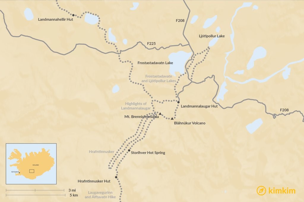
### Highlights of Landmannalaugar: A Four-Hour Immersion
This popular 4-hour hiking trail begins at the main hut in Landmannalaugar, providing a convenient starting point for your exploration. The trail leads you through the mesmerizing Laugahraun lava field, a landscape sculpted by ancient volcanic activity. You’ll then traverse Vondugil Canyon, a breathtaking gorge with dramatic rock formations and stunning views.
The highlight of this hike is the ascent to the multicolored summit of Mt. Brennisteinsalda. The mountain’s steaming vents and sulfur deposits create a unique and unforgettable experience. From the summit, you can marvel at the panoramic views of the surrounding landscape.
The trail then leads down Grænagil Gorge, a lush green canyon with rhyolite rocks in a dazzling array of colors. If you have time and energy, a hike up Bláhnúkur Volcano is highly recommended. This 60,000-year-old gray volcano offers even more panoramic views of the valley. The hike to the peak takes approximately one hour, but the reward is well worth the effort. From the summit, you can view the medieval lava field and the kaleidoscopic colors of the gray, pink and orange hills.
* Distance: 5-6 miles (8-10 km)
* Duration: 4 hours
### Laugavegurinn: A Multi-Day Highland Adventure
The Laugavegur hike to Thorsmork is a demanding, multi-day trek that immerses you in the heart of the Icelandic highlands. This challenging but rewarding hike takes you through a variety of landscapes, from volcanic plains and rainbow-colored hills to glaciers, canyons, sandy areas, snowbound plateaus and freezing rivers.
During the high season, which typically runs from late June to August, the trail is well-marked with marker sticks placed approximately every 200 meters. However, due to the heavy traffic on the trail, it is unlikely that you will lose your way.
For those seeking an even greater challenge, the hike can be extended by 15.5 miles (25 km) through beautiful scenery to reach Skógar. This extension will add an additional day or two to your journey.
You can hike Laugavegur by yourself, with a guide, or with a sherpa who will transport your heavier packs from one campsite to the next, allowing you to carry only your daypack. If you plan to stay in one of the huts along the way, it is highly recommended that you make reservations in advance, as they tend to fill up quickly. Huts are available at Landmannalaugar, Hrafntinnusker, Álftavatn, Hvanngil, Emstrur and Þórsmörk.
* Distance: 34 miles (55 km)
* Duration: 2-4 days
### Hrafntinnusker: A Volcanic Landscape
If you prefer not to hike all the way to Thorsmork, a shorter option is to hike to Hrafntinnusker. This massive and dramatic mountain in the highlands is located just a few hours from Landmannalaugar.
Hrafntinna is the Icelandic word for “obsidian,” and the dormant volcano is named for the black glass rocks that are scattered across its slopes. This is also a relatively large active geothermal area, so you may see plumes of smoke rising from deep under the ice. To reach Hrafntinnusker, hike south from Landmannalaugar.
* Distance: 7.5 miles (12 km)
* Duration: 3-4 hours
### Roundtrip Hike from Landmannalaugar to Álftavatn: A Journey Through Valleys, Mountains, and Glaciers
This beautiful trail will take you across valleys, mountains, and glaciers, at a pace of about 7.5 miles (12 km) per day. Hike from Landmannalaugar through the Laugahraun lava field, onto the slopes of Brennisteinsalda and its plateau with panoramic views. After 3-4 hours, you’ll arrive at the hot spring Stórihver. After a soak, hike onto Höskuldsskáli hut, which sleeps about 36 people. There may be snow and thick fog, so proceed with caution. From the hut, you can explore the ice caves about 1 mile (1.5 km) away.
On the second day, the first part of the trail will lead you through a valley with small ravines. If visibility is good, hike up Háskerðingur mountain. Soon you’ll arrive in an area with dark palagonite mountains, blue glaciers, and lush vegetation. The trail down Jökultungur is steep but is the only way to the banks of the Grashagakvísl river. From there, it’s a breezy, flat walk to the two huts beside Lake Álfavatn.
* Distance: 30 miles (48 km)
* Duration: 4 days
### Frostastadavatn and Ljótipollur Lakes: A Scenic Detour
Travel along the dirt road northwest from Landmannalaugar, then turn off at the signpost for Lake Frostastadavatn. This small climb takes you to this magnificent fishing lake, with scenic views of Norðurnámur Hill. You can hike around the rim in about 3 hours, or climb up the hill for a different perspective.
Descending from the ridge, hike along the flat road until you reach Ljótipollur, the “Ugly Pond.” Despite its name, this lake is actually quite beautiful. The terrain is characterized by rocks in hues of rust and green. The water comes from silted groundwater below the surface of the crater, giving it a beautiful turquoise color.
* Distance: 7 miles (11 km)
* Duration: 3-4 hours
## More Activities: Beyond Hiking in Landmannalaugar
While hiking is the main draw of Landmannalaugar, there are other activities to enjoy in this remarkable region.
You can rent a horse to cross certain trails that are otherwise difficult to navigate on foot. Horse rental facilities are typically open starting on July 1 each year. Experience the thrill of riding an Icelandic horse through meadows, green highlands, and past colorful mountains.
Fishing is also allowed in the mountain lakes, provided you have a fishing license. Be sure to pack your own fishing rod and try your luck at catching some of the local fish. If you’re joining a tour guide, they may take you to the crater lake Ljótipollur for a hike and fishing fun.
At the trailhead of the Laugavegur route, you’ll find the Landmannalaugar Countryman’s Pool, a natural hot spring where you can warm up or chill out after a long day of hiking. Head to the edge of the Laugahraun lava field, where hot water streams mix with natural cold water, creating the ideal temperature of 96-104°F (36-40°C).
## Where to Stay: Accommodation Options in the Fjallabak Nature Reserve
In the Fjallabak Nature Reserve, campsites are restricted to designated locations at Landmannalaugar, Landmannahellir and Hrafntinnusker. Bring your own tent or reserve one of the Mountain Huts operated by Ferðafélag Íslands. Be sure to book well in advance during the summertime, as these tend to fill up quickly. Pack a sleeping bag no matter where you’re sleeping, as the huts do not stock linens.
On-site facilities at Landmannalaugar huts also include a shower block, and the area is sheltered from wind and rain by a massive rhyolite cliff. Outside the reserve, the highland motel Hrauneyjar is another option for those seeking more comfortable accommodation.
The best part of camping at Fjallabak are the natural hot springs that emerge into a meadow from underneath a 15th-century lava flow, where they then mingle with a cooler stream. Wade or swim up this stream until the water temperature increases and find the perfect spot to enjoy a relaxing soak. Keep in mind that the hot springs can get busy on weekends and when the Reykjavík bus arrives between 1 and 3 pm, so plan your soak accordingly to avoid the crowds.
## Tips Before You Go: Essential Information for Your Trip
During peak season, the “Mountain Supermarket” is open – a converted school bus that doubles as a café and food store. Occasionally, they may offer local fresh fish such as Arctic Charr, caught in a mountain lake. However, it is best not to rely on this shop being open or offering reasonable prices, so it is wise to stock up on basic trail rations before you leave town.
If you are driving, it is strongly advised to use a 4-wheel-drive vehicle, as normal car rentals are not covered by local insurance policies in the highlands. Be sure to have plenty of gas, as the nearest station is nearly 40 km from Landmannalaugar.
The Fjallabak Natural Reserve is only open in summer. Be prepared for various weather conditions, including low temperatures, high winds, heavy rain, and snow, which can occur at any time of year. If you hike during the colder months, such as May and September, be aware that the increased snow cover may make it difficult to navigate in unfamiliar territory.
B-1157