
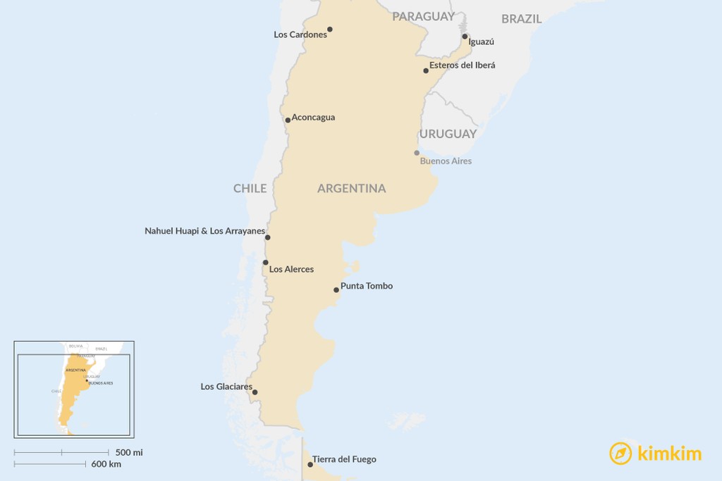
Argentina contains dozens of national parks within its borders, and visiting at least a few of them (there are 33 in total) is a must. This list of favorites spans the country, from the massive cacti of Los Cardones in the north to the trekker’s paradise of Tierra del Fuego in the south. It also encompasses a wide variety of landscapes—glaciers and ice fields, lakes and river valleys, iconic Iguazú Falls, and beyond.
Los Glaciares National Park: A Frozen Wonderland
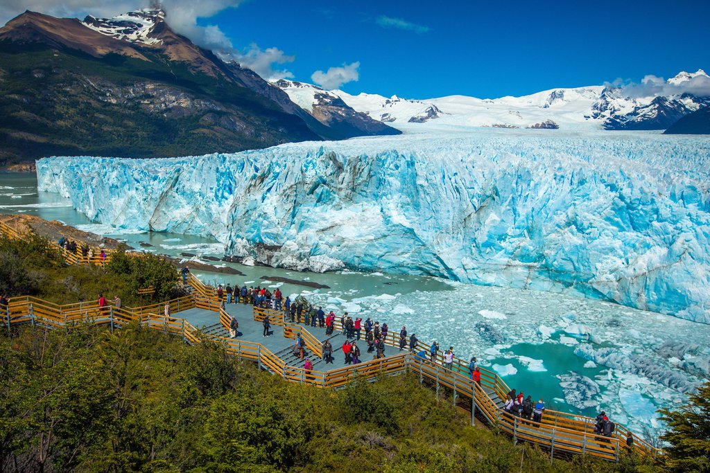
Los Glaciares National Park, a breathtaking expanse of natural beauty, was officially established in 1945, solidifying its place as a protected area of immense ecological significance. Nestled within the embrace of the Austral Andes of Argentina, this remarkable park is a testament to the raw power and serene beauty of nature. Positioned just southwest of Santa Cruz Province, the landscape is dramatically defined by a captivating collection of Prussian-blue lakes. Among these shimmering bodies of water are the iconic Lago Argentino and the equally stunning Lago Viedma, each reflecting the majestic peaks that surround them. The region is further characterized by its untamed, wild rivers, carving their paths through the terrain, and the presence of mammoth glaciers, ancient rivers of ice that slowly sculpt the land. These natural wonders combine to create a panorama of unparalleled grandeur.
The geography of Los Glaciares National Park is diverse and intriguing. The western section of the park, encompassing nearly half of its total area, remains largely concealed beneath an extensive blanket of ice and snow, a testament to the region’s glacial dominance. In stark contrast, the eastern portion of the park presents a different extreme, unfolding into the vast and seemingly endless expanses of the Patagonian steppe. This contrast between ice and open plains highlights the dynamic nature of the park’s environment.
The name “Los Glaciares,” meaning “The Glaciers” in Spanish, is directly inspired by the immense masses of ice that constitute significant portions of the Southern Patagonian Ice Field. This ice field represents the largest continental ice extension outside of Antarctica, underlining the region’s crucial role in global climate systems. Within this expansive icy realm, Los Glaciares National Park boasts an impressive collection of natural wonders. There are 47 major glaciers and over 200 smaller glaciers, each a unique and impressive spectacle. Without a doubt, the most celebrated and visited glacier within the park is the magnificent Perito Moreno Glacier. This colossal ice formation spans an area of approximately 250 square kilometers, representing a monumental mass of ice. What makes Perito Moreno particularly fascinating is that it’s one of the few advancing glaciers in the region, defying the general trend of glacial retreat observed worldwide.
The advancing nature of the Perito Moreno Glacier creates a remarkable phenomenon. The immense pressure generated by this forward movement causes great chunks of ice to periodically break off from the glacier’s face, dramatically crashing into the surface of Lago Argentino below. This captivating process, known as “calving,” is a sight to behold, a demonstration of the immense power contained within the ice. A visit to Los Glaciares National Park offers a high probability of witnessing this incredible spectacle firsthand, an unforgettable experience that connects you to the forces of nature.
Beyond its glaciers, Los Glaciares National Park is rich in biodiversity. It supports a diverse array of plant life, including the verdant lenga forests, the hardy ñira shrubs, and the towering guindo trees. These forests provide vital habitats for a variety of animal species. As mentioned before, the park also encompasses expanses of Patagonian steppe, offering yet another distinct ecosystem. The fauna of Los Glaciares National Park is equally impressive, with iconic species such as condors soaring overhead, black-chested buzzard eagles patrolling the skies, and rheas (a South American relative of the ostrich) roaming the plains. Guanacos, a type of llama native to South America, are also frequently sighted, as are the elusive pumas, apex predators that roam the landscape.
The closest city to Los Glaciares National Park is El Calafate, a vital hub and the central point for all activities and excursions into the park. El Calafate provides essential services and amenities for visitors, serving as a gateway to the natural wonders that await within Los Glaciares.
Aconcagua Provincial Park: Reaching for the Sky
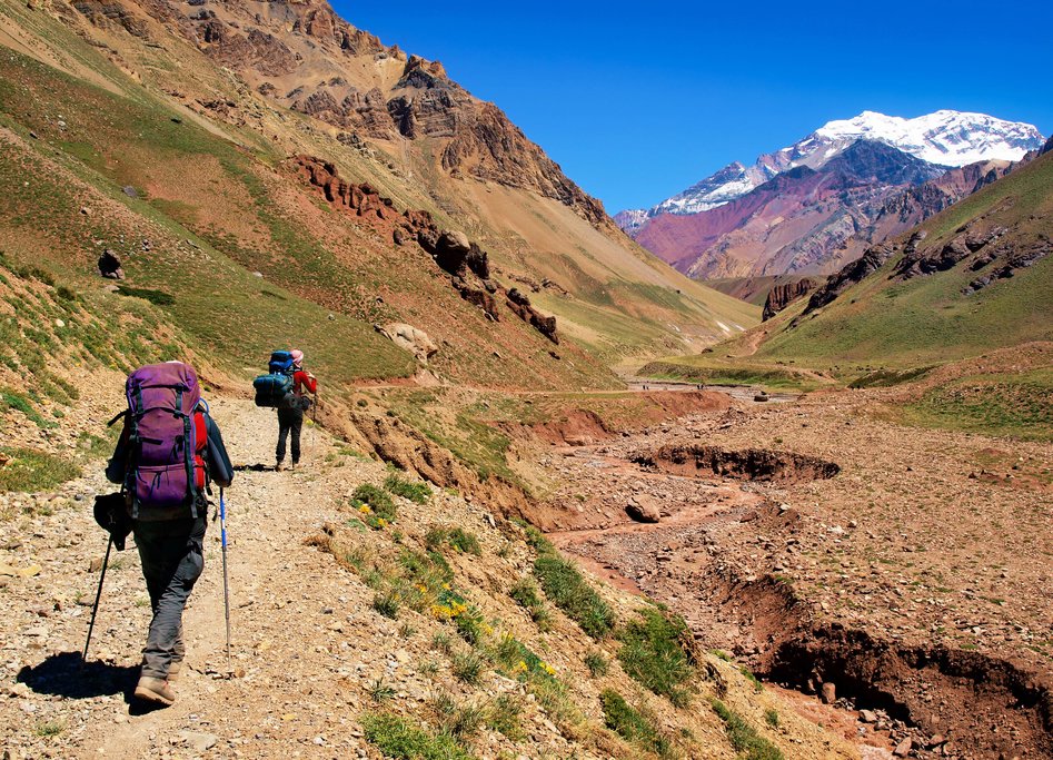
Aconcagua Provincial Park, a haven for adventurers and nature enthusiasts alike, is dramatically situated in the heart of the Andes Mountains. Located approximately 185 kilometers (114 miles) from the vibrant city of Mendoza, the park lies near the border with Chile, sharing the dramatic mountain range. This vast protected area encompasses nearly 200,000 acres, a significant expanse that safeguards a wealth of natural treasures. The park is renowned for its impressive mountain peaks, which dominate the skyline and offer challenging yet rewarding experiences for climbers and hikers. However, none of these peaks are as iconic or imposing as the park’s namesake, Mt. Aconcagua. Rising to a staggering height of 6,980 meters (22,900 feet) in altitude, Aconcagua stands as the highest mountain in the western hemisphere, a true titan of the Andes.
Aconcagua Provincial Park is unequivocally a destination for thrill-seekers and adventurers. It draws a diverse crowd of mountain climbers, skiers, hikers, and outdoor enthusiasts, all driven by a shared desire for high-altitude exploration and adrenaline-pumping challenges. For those who aspire to ascend the majestic Aconcagua, there are two primary routes to consider, each offering a unique perspective and set of challenges. Climbers can approach the mountain via the pass at the Quebrada de Horcones, a rugged and scenic route. Alternatively, they can choose to ascend via the Quebrada de las Vacas, another challenging but rewarding path to the summit. Furthermore, Aconcagua offers different routes tailored to various skill levels, ensuring that climbers of varying experience can find a suitable and safe ascent.
However, Parque Aconcagua is more than just a single mountain. It is a diverse and multifaceted landscape encompassing various glaciers, rivers, and watersheds, all contributing to the park’s ecological richness. The park also provides habitat for a variety of high Andean fauna, including the iconic condors, soaring high above the peaks, and the elusive pumas, roaming the rugged terrain. Adding to the park’s allure are ancient Incan archeological sites, offering glimpses into the region’s rich history and cultural heritage. One notable site is the Puente del Inca (Inca Bridge), a remarkable natural geological formation that once arched gracefully over hot springs. These hot springs were historically used by the Incas for bathing during pre-Hispanic times, highlighting the area’s significance to indigenous cultures.
Nahuel Huapi & Los Arrayanes: Lakes, Forests, and Ancient Trees
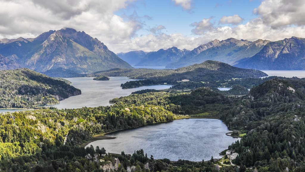
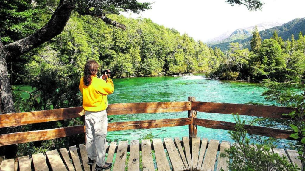
Nahuel Huapi National Park, established in 1934, holds the distinction of being the oldest national park in Argentina, a testament to the country’s early commitment to environmental conservation. The park encompasses the stunning Nahuel Huapi Lake and the surrounding foothills of the Patagonian Andes, creating a landscape of unparalleled beauty. Geographically, Nahuel Huapi National Park falls squarely within the northern Patagonian Andean Zone, a region characterized by three distinct types of landscapes. The Altoandino zone, with its perpetual snow cover above 1,600 meters (5,249 feet), presents a high-altitude environment. The Andino-Patagónico zone, located in the lower hills, offers a more temperate and forested landscape. Finally, the Patagonian steppe stretches out to the east, providing a vast and open environment. Notably, the park also includes small pockets of Valdivian rainforest, adding to its ecological diversity.
Everywhere you look within the park, you’ll discover seemingly endless lakes, cascading waterfalls, snow-clad peaks, and native forests, a symphony of natural elements that create a truly immersive experience. The park is teeming with diverse fauna, including playful river otters, elusive huemuls (south Andean deer), stealthy cougars, and vibrant Magellanic woodpeckers, each adding to the area’s biodiversity. Bariloche, a charming city nestled on the shores of Lake Nahuel Huapi, is widely regarded as the “gateway to Patagonia.” It is also known as the chocolate and honeymoon capital of Argentina, a reputation earned through its Swiss-immigrant heritage and its undeniably picture-perfect setting.
Los Arrayanes National Park, once an integral part of the Nahuel Huapi National Park, was established as a separate entity in 1971. This separation was motivated by a pressing need to protect the native forest of Arrayanes (Luma Apiculata), a rare and ecologically significant tree species. These ancient trees, some reaching up to 300 years in age, are characterized by their distinctive cinnamon-colored bark, adding to their visual appeal. To ensure the long-term preservation of these fragile trees, a special trail has been constructed to protect the soil and roots from damage. This trail is located just one mile away from the lakeside village of Villa La Angostura, in Neuquén Province, making it easily accessible. Furthermore, the park can be reached by boat from various points around Nahuel Huapi Lake, offering a scenic and convenient mode of transportation.
Tierra del Fuego: Land of Fire and End of the World
Tierra del Fuego, a name that translates to “Land of Fire” in English, carries a historical significance tied to the observations of early European explorers. As they sailed past this southernmost region by boat, they witnessed the native bonfires illuminating the shores, creating an impression of a land perpetually ablaze. However, the human history of Tierra del Fuego extends far beyond the arrival of Europeans. The earliest human settlements in this region date back to approximately 8,000 BCE, revealing a rich and ancient indigenous presence. Europeans first arrived in the region in 1520 with Magellan’s expedition, marking a pivotal moment in the region’s history. The Strait of Magellan, a crucial waterway connecting the Atlantic and Pacific Oceans, remains one of the most vital maritime routes in the region.
During the second half of the 19th century, the local indigenous populations faced displacement and disruption as the region underwent significant economic and social changes. This period witnessed a boom in sheep farming, transforming the landscape and economy of Tierra del Fuego. The discovery of gold also triggered a gold rush, attracting prospectors and further altering the region’s demographics. In contemporary times, the main industries in Tierra del Fuego encompass petroleum, tourism, and manufacturing, reflecting the region’s diverse economic activities.
The Tierra del Fuego National Park primarily caters to tourism, offering visitors the opportunity to explore and appreciate the region’s unique natural environment. The park is part of a vast archipelago that covers approximately 48,100 square kilometers, encompassing a multitude of islands and waterways. The largest island in this archipelago is Isla Grande de Tierra del Fuego, which is divided between Argentina and Chile, highlighting the shared geographical context. The archipelago extends all the way down to Cape Horn, one of the southernmost points in South America.
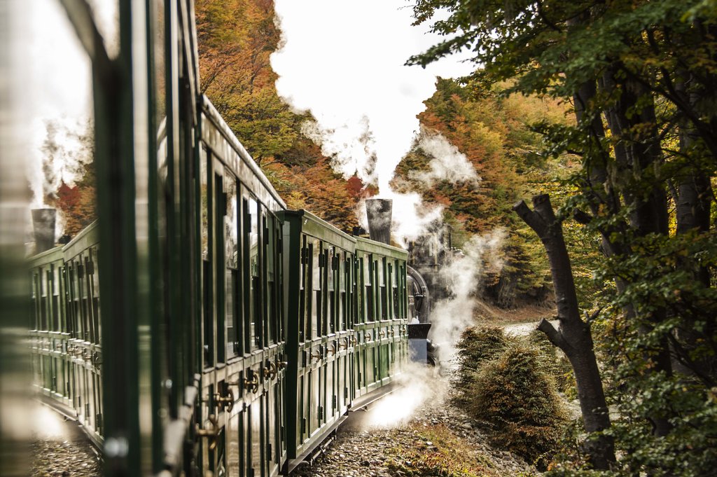
Argentina’s National Route 3 connects this region from the city of Ushuaia, the southernmost city in the world, along the picturesque Pipo River Valley. This route also leads to the destination of the End of the World Train, famously known as the “world’s southernmost train.” This historic train, once used for logging purposes, now operates as a tourist attraction. It runs a grand total of four miles, offering a scenic nature sightseeing excursion from just outside Ushuaia. The train briefly enters the park, providing passengers with glimpses of the region’s natural beauty.
Tierra del Fuego boasts a diverse array of animal species. Among the most notable inhabitants of this archipelago are austral parakeets, seagulls, guanacos, foxes, kingfishers, condors, king penguins, owls, and fire crown hummingbirds. These species contribute to the region’s rich biodiversity and offer captivating wildlife encounters. Only 30% of these islands are covered in forests, which are classified as Magellanic subpolar forests, adapted to the region’s cool and damp climate. The northeast portion of Tierra del Fuego is characterized by steppe and cool semi-desert environments, reflecting the region’s varied landscapes. Furthermore, Tierra del Fuego serves as a significant embarkation point for cruises to Antarctica and South Georgia and the South Sandwich Islands, making it a gateway to the icy continent.
Punta Tombo: Penguin Paradise

The Punta Tombo Provincial Reserve, a remarkable haven for wildlife, is home to the largest colony of Magellanic penguins outside of Antarctica. Estimates suggest that the penguin population here numbers around one million, making it a truly impressive sight. This reserve is situated on a peninsula approximately one hour south of the city of Puerto Madryn, located on Argentina’s Atlantic coast. Punta Tombo has been a protected reserve since 1979, reflecting a long-standing commitment to penguin conservation. It is also an integral part of the new marine national park at the Gulf of San Jorge, further enhancing its protected status.
Each year, in September, thousands of penguins embark on a remarkable journey, arriving on this Patagonian coast from as far away as Brazil. They stay in Punta Tombo until mid-March, engaging in breeding and raising their young. The peak season for observing the penguins is after November, once the adorable baby penguins are born. The highlight of a visit to Punta Tombo is the opportunity to walk right alongside the penguins, allowing for close-up views of these fascinating creatures in their natural environment. A network of trails and boardwalks traverses this arid, gravelly coastline, providing safe and accessible viewing areas. The landscape is characterized by small shrubs and burrows where the penguins construct their nests, adding to the unique character of the reserve. Other fauna found in Punta Tombo includes Patagonian hares, foxes, and cormorants, contributing to the reserve’s biodiversity. Furthermore, it is common to spot whales and dolphins swimming offshore, adding to the coastal charm.
Esteros del Iberá: Argentina’s Bright Waters
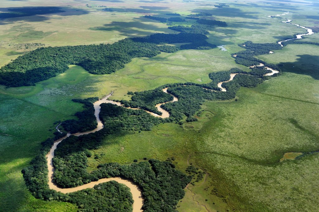
The Iberá Wetlands, a vast and ecologically significant region, is located in northern Argentina’s Corrientes Province. Covering approximately 3.2 million acres, this extensive wetland is one of the most important freshwater reservoirs on the continent. Notably, it is the second-largest wetland in the world, surpassed only by Brazil’s Pantanal. Iberá is currently undergoing a transition to become a fully protected area, with ongoing plans to upgrade its status to a national park, reflecting a commitment to its long-term preservation.
The word “Iberá” originates from the indigenous Guaraní ý berá, which translates to “bright water.” This evocative name reflects the character of the wetlands, which are comprised of a diverse mix of bogs, swamps, lakes, lagoons, and waterways, creating a complex and interconnected ecosystem. The wetlands are situated within a subtropical and tropical environment, contributing to their exceptional biodiversity. Iberá is the natural home of an abundance of wildlife, including alligators, marsh deer, and hundreds of bird species, making it a paradise for nature enthusiasts.
This destination is particularly recommended for conservation tourism, emphasizing responsible travel that supports the preservation of the region’s natural and cultural heritage. The wetlands can be accessed from the nearby city of Posadas, providing a convenient gateway to this remarkable natural area.
Los Cardones: Cactus Country
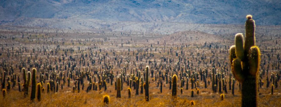
Cardones National Park, established in 1996, is located in Salta Province. Encompassing 659 square kilometers, the park serves as a protective zone for four regions of distinct ecological diversity. These regions include the Altos Andes, with their high-altitude environment, the Puna, a high-altitude arid plateau, the Monte de Sierras, a shrubland ecosystem, and Bolsones and Yungas, characterized by mountain peaks reaching up to 5,000 meters (16,404 feet). The park’s name is derived from the Cardon Grande Cactus, which grows abundantly in the area, evoking images of the American West with their towering presence.
The arid desert and mountain landscapes within the park offer a diverse array of painted hills and unique flora, creating a visually stunning environment. Rivers meander through the park, providing oases of life in the arid landscape. A popular excursion involves exploring the caves around the Calchaquí River, offering an adventurous experience. Notably, dinosaur fossils and tracks have been discovered in this region, adding a paleontological dimension to the park. The park stretches from Salta to the Calchaquí Valley and towns such as Cachi and Cachi Adentro. Visiting these villages provides valuable insights into the traditional lifestyle of the locals and offers an opportunity to sample the province’s delicious wines.
Los Alerces: Ancient Giants
Los Alerces National Park, a gem of Argentine Patagonia, is situated in the Andean region of Chubut Province. Designated as a UNESCO World Heritage Site since 2017, the park was established in 1937 with the primary goal of protecting the Alerce (Fitzroya cupressoides) tree, a deciduous evergreen also known as “lahuán” by the native Mapuche people. The park covers 2,360 square kilometers, encompassing a variety of distinct ecosystems. These include Valdivian temperate rainforest, Andean-Patagonia forest, high-Andean Steppe, and Patagonian steppe, each contributing to the park’s ecological richness.
One of the primary reasons to visit Los Alerces National Park is to immerse oneself in nature and marvel at the towering Alerces trees, which can grow to an impressive height of 50 meters (164 feet). These remarkable trees are not only tall but also possess incredible longevity, with some specimens dating back 3,600 years. This makes them the oldest trees in Argentina and among the oldest living organisms on Earth. However, it’s important to note that Alerces trees grow extremely slowly, adding only about 1 mm per year. The name “Alerce” originated from a historical misunderstanding by the Spanish, who mistakenly identified them as the same tree as the European Alerce (larch). This is why it’s also referred to as “False Patagonian Cypress.” In indigenous traditions, the tree is known for its anti-inflammatory properties, and the Mapuche name “Lahuán” translates to “cure” or “remedy.”
Los Alerces National Park is also characterized by a network of many lakes and rivers. These include Futalaufquen Lake and Kruger Lake, as well as rivers Arrayanes, Futaleufú, and Menendez. This park offers a range of outdoor activities, including hiking, camping, fishing, and rafting/kayak excursions, catering to various interests.
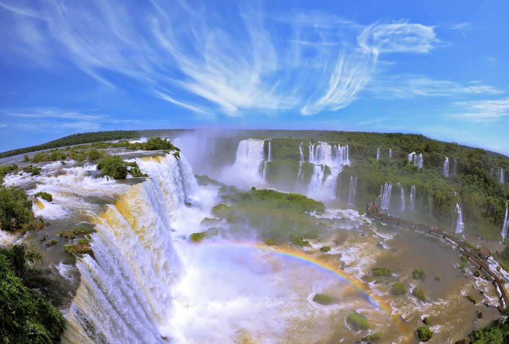
Iguazú: A Symphony of Water
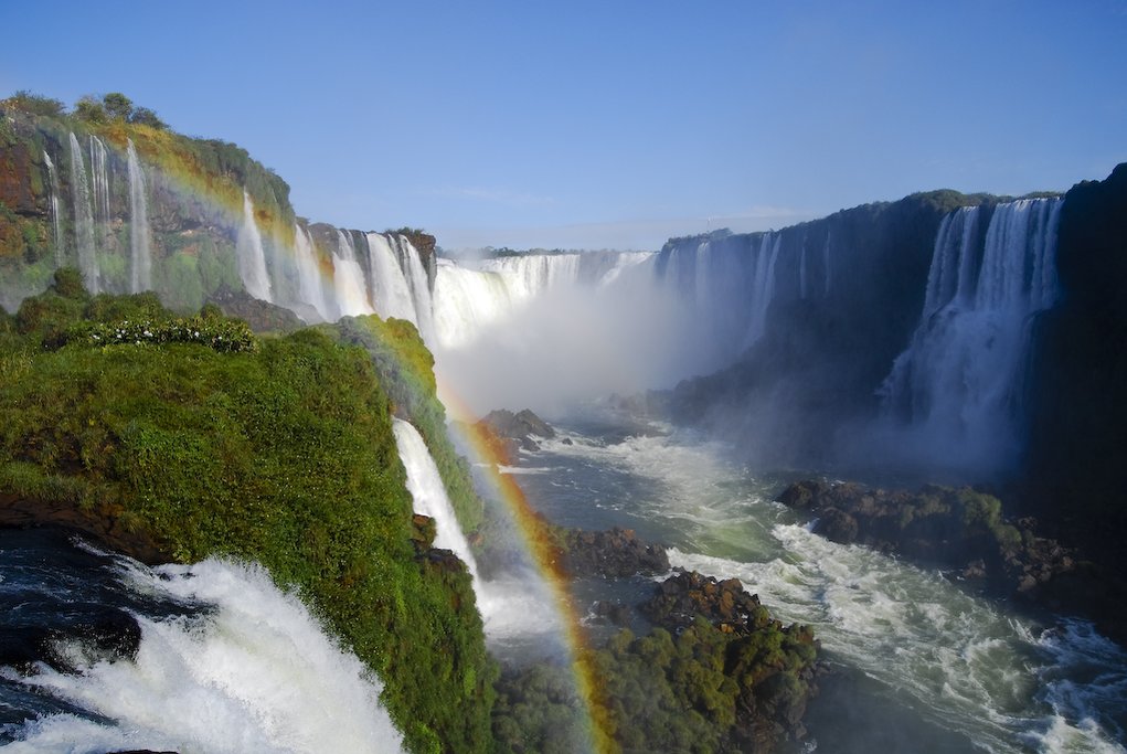
Iguazu National Park, spanning 672 square kilometers, is located in Argentina’s northern Misiones Province. It is home to one of the New Seven Wonders of the World: the magnificent Iguazú Falls. This network of 275 waterfalls is second in size only to the immense Victoria Falls in southern Africa. Established in 1934, Iguazú Falls has been designated as a UNESCO World Heritage Site, recognizing its exceptional natural significance. The falls attract approximately two million visitors each year, drawn by their unparalleled beauty. Argentina shares a portion of the falls with Brazil, and the Paraguayan border is also nearby, making it a tri-border region.
The word “Iguazu” originates from indigenous Guaraní and Tupi tribes and means “big” and “water,” a straightforward yet apt description of the falls. The Paraná River (South America’s second largest river after the Amazon) feeds these waterfalls, which cascade from varying heights. According to indigenous legend, the falls were created when a furious god divided the river into two levels to prevent the escape attempts of a beautiful woman who was betrothed to marry him.
The most awe-inspiring feature of Iguazú Falls is undoubtedly the site known as Garganta del Diablo (“Devil’s Throat”). A wooden boardwalk leads visitors to a viewing platform at the edge of the falls’ upper plateau, offering breathtaking views of the thundering waters plunging 80 meters (262 feet) straight down. The Devil’s Throat effectively showcases the awe-inspiring power of Mother Nature. Fun fact: when the river’s waters are at their highest, Iguazú becomes the largest waterfall on the planet, with a maximum-recorded water flow of 452,000 cubic feet per second, surpassing Niagara Falls.
Iguazú National Park is also home to a wide array of exotic flora and fauna, many of which can be easily observed from the park’s trails. Some of the birds and mammals commonly spotted here include jaguars, ocelots, tapirs, giant anteaters, tufted capuchin monkeys, coatis, black-fronted pipping guans, solitary tinamou, harpy eagles, toucans, and caimans. Additionally, the park boasts over 2000 species of plants, adding to its ecological diversity.
B-75